Abstract
Among the cross-boundary rivers of two south Asian neighbors Bangladesh and India, the Himalayan river of Ganges occupies a strategically significant place. The largest of the shared rivers is also a major driver in the ecology and livelihood of both territories. A dispute over sharing the Ganges water started with India’s construction of a barrage at Farakka. In the face of increasing water stress and population explosion, the dispute grew bigger and went through series of negotiations. The long-awaited end of the dispute came in 1996 with Ganges Water Sharing Treaty to be operational for 30 years, which favored the hydro-interests of India and failed to solve the environmental problems of Bangladesh. A demonstration of political goodwill resulted in the exercise of unilateral water diversion. Leaving the past, some adjustments in the treaty conditions at the end of the treaty period can enhance regional coordination between the two. Meanwhile, the cooperative political atmosphere, the treaty created can play a role to resolve the unsolved and emerging issues between the two countries.
Keywords: Ganges water sharing treaty; Farakka Barrage; Transboundary rivers; Unilateral water diversion; Regional cooperation
Introduction
A popular practice in the transboundary water literature is to note that 263 river basins and such water bodies pose a unique challenge for 145 countries whose territory partially or entirely lies within the transboundary watershed (Thomas, 2017). Bangladesh, often called the land of rivers, cannot be overlooked in terms of transboundary water resource management. Being a lower riparian and extremely dependent country on transboundary water, Bangladesh is a hotspot to examine international river conflicts and crises. Such a conflict was created between Bangladesh and neighboring India regarding the construction of a barrage over the mighty Ganges, on which the balance of the natural ecosystem, as well as hundreds of millions of people’s lives and livelihoods, depends. India showed unilateral dominance in the bilateral agreement with Bangladesh, which was evident through its diversion of the natural flow of the Ganges. While India’s move left Bangladesh with a hydro-ecological catastrophe, it also opens doors for upgrading mutual understandings and cooperation. Shedding light on the background of the dispute, this paper shows the pathway through which Bangladesh concluded its whacking journey of negotiation for 30 years with India regarding Ganges’ water sharing. It also examines the resultant impacts of the water sharing agreement on the hydrogeology and political environment of Bangladesh.
Ganges: the mighty transboundary river of South Asia
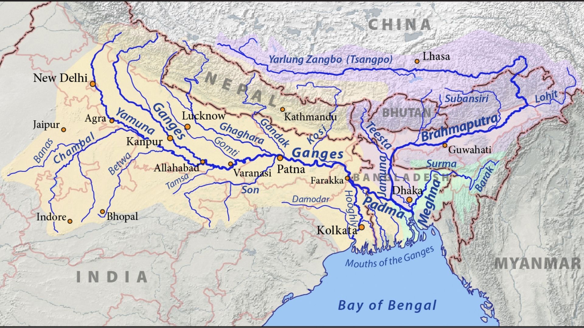
Transboundary waters refer to lakes, river basins, and aquifers that are shared by at least two or more countries, supporting the livelihood of a large number of people (UN Water, 2021). River basins crossing political borders account for approximately 60% of the world’s freshwater flow as well as home to 40% of the world population (Giodano et al., 2014). Transboundary rivers provide enormous ecosystem services including the production of food and energy and flood mitigation (Rahman et al., 2019). Bangladesh, a small South Asian country burdened with a huge population has the highest number of transboundary rivers in the world, 57, with its two neighboring countries, India and Myanmar. The close neighbors Bangladesh and India share 54 rivers (Baten and Titumir, 2015), including two of the world’s largest rivers, the Ganges and the Brahmaputra.
The 1,087,000 sq km giant basin area of the Ganges covers India, Nepal, Bangladesh, and China (Rahman et al., 2019). The river Ganges with a length of 2600 km rises in the Gangotri glacier of Uttarkhand, India. It enters West Bengal province through Bihar, where two arms of the river have been created. Flowing east, the left main arm enters Bangladesh. Mahananda is the only tributary inside Bangladesh, which joins the Ganges. Entering Bangladesh, the river flows another 113 km path before it joins the Brahmaputra. The combined course of these two rivers (the Ganges and the Brahmaputra) is known as the Padma, which further joins the Meghna River. The combined course of the three rivers continues from the confluence with the name ‘lower Mrghna’ and drains into the Bay of Bengal.
The river Ganges is of great significance in terms of the socio-economy of the co-basin countries. Bangladesh, as the most downstream country of the Ganges basin, heavily depends on the river for the supply of dry season irrigation water and salinity level regulation in its south-western part (Rahman and Rahaman, 2017).
Construction of Farakka barrage and beginning of the dispute
In the face of climate change-induced hydrologic variability and increasing pressure on freshwater, the potential for water conflicts across international boundaries is rising (De Stefano et al., 2017). It is not surprising to see a dispute regarding transboundary river water in South Asia when the physical and socio-economic setting of the related terrestrial boundaries highly rely on that water. Riparian countries are in an advantageous position in this regard due to their geographic location. They also have varying views on transboundary water resources regarding their ownership, distribution, and use (Rahman et al., 2019). In 1951, the dispute regarding Ganges’ water sharing arose when the upper riparian country India decided to construct a barrage at Farkka, West Bengal. The initial aim of the construction project was to divert water from the Ganges to the river system of Bhagirathi-Hooghly so that the Kolkata port regains its navigability which was lost due to heavy natural siltation (Mirza, 2004).
The Farkka barrage was constructed 17 km upstream from Bangladesh, which India started operating in 1975 (Hassan, 2019). Pakistan had been critical of the project right from the proposal phase, fearing that the enhanced flow into the Bhagirathi-Hooghly will reduce the flow into the Sundarbans delta in the dry season. Bangladesh got liberated from Pakistan in 1971 and the tension regarding the Ganges was forced to reduce a little. India’s relationship with newly born Bangladesh passed its ‘honeymoon phase’ since there was no differing perceptions at sight (Singh, 2018). However, with the assassination of Bangladesh’s president Sheikh Mujibur Rahman in 1975 and India’s unilateral operation of the barrage in 1976 the situation took a U-turn. India started diverting the Ganges water in 1976 without signing any agreement specifically on sharing the water of the Ganges. Such a unilateral decision shocked Bangladesh. Questions have been rising since then that India built it for its own benefit not considering the disastrous effects it can have on neighboring Bangladesh (Hassan, 2019).
Resolving the dispute: stages of negotiation between India and Bangladesh
The negotiation regarding the Ganges water sharing has been on the run for over 50 years (Mirza, 2004). The different stages of negotiation between India and Bangladesh are as follows-
- Stage 1 ( 1951-1970): Characterized by a formal protest by Pakistan (Bangladesh was part of Pakistan till March 25, 1971), which later set the ground for discussions from both sides. In 1961, the construction started.
- Stage 2 (1972-1976): Signing of a 25-year friendship treaty between Bangladesh and India for mutual cooperation in water resources development. The construction got completed in 1974 and India started unilateral diversion in 1976. Bangladesh raised the issue in the UN and Commonwealth regarding the environmental and human costs involved in the diversion.
- Stage 3 (1977-1982): The first water-sharing agreement was signed between the two countries. It said that Bangladesh would get water divided into 10 day periods, in the dry season (January to May).
- Stage 4 (1982-1988): In 1982 and 1985, the Memoranda of Understanding (MoU) was signed between the two countries with some modifications of the 1977 Agreement.
- Stage 5 (1988-1992): India resumed its unilateral withdrawal of water. Negotiations went on without a significant outcome.
- Stage 6 (1993-1995): India again starts the unilateral withdrawal of water, the issue again was raised in the UN.
- Stage 7 (1996 onwards): A major step toward concluding the dispute was the 30-year treaty signed in December 1996. Based on the treaty, the flow would be shared based on a unique formula.
Table 1: Gangeswater sharing formula
| Availability at Farakka | Share of India | Share of Bangladesh |
| 70,000 cusec* or less | 50% | 50% |
| 70,000-75,000 cusec | Balance of flow | 35,000 cusec |
| 75,000 cusec or more | 40,000 cusec | Balance of flow |
*Cusec = water flow in cubic feet per second
(Source: Rasheed, 2008)
Concerns on the 1996 treaty: Bangladesh perspective
Despite having the unique water-sharing formula, the efficiency of the treaty remained controversial since there was low availability of flow during the post treaty period. Criticisms came from Bangladesh sides on the following –
A significant lacking in the 1996 treaty is the absence of a direct guarantee clause for Bangladesh. The treaty of 1977 however had a guarantee clause ensuring that Bangladesh would get a minimum of 80% flow during extremely low periods at Farakka (Salman & Uprety, 1999). Furthermore, the treaty of 1996 says, a drop below 1,416 m3/s on the available 10-day average flow will make the two countries obliged to meet the requirements. So if India could manage the flow to be less than 1,416 m3/s, then they would not be obliged to ensure the guaranteed flow to Bangladesh.
The allocation of the Ganges water is based on a volumetric measurement in the 1996 treaty. The water allocation regime’s flexibility is disturbed by the volumetric allocation mechanism, which also results in multifarious problems (Tir & Stinnett, 2011).
Hardinge Bridge in Bangladesh resides in a location that could verify whether Bangladesh is receiving the flow it was supposed to get according to the treaty. Surprisingly, the flow at the Hardinge bridge was lower than expected, which was supposed to be higher because of the inflow of the tributary Mohanonda, which is between the Farakka barrage and the Hardinge bridge (Rahman et al., 2019).
The average flow at Farakka between 1949 and 1988 was used to formulate the key traits of the 1996 treaty, where the inevitable issue of climate change was overlooked. Researchers predict that the frequency, intensity, and magnitude of rainfall in the Ganges basin will be affected by climate change, and the basin can have reduced dry season in the future (Pervez & Henebry, 2015). A proper investigation was not run to predict a reliable future flow across the basin, which may cause Bangladesh to be deprived of its rightful share of Ganges water.
Analyzing the water-sharing agreements of 1977 and 1996, Nishat and Faisal (2000) came to the point that none of the agreements improved water availability in Bangladesh during the lean season, and the 1996 treaty was a poorer performer than 1977’s agreement.
The post-treaty period in Bangladesh: a focus on hydrogeology
The flow alteration at Farakka caused some notable impacts in the hydro-ecological environment of Bangladesh. Water and food security in southwestern Bangladesh is on the verge of collapse as a result of the barrage. The lives and livelihood of the local people have also been severely disrupted.
Salinity intrusion is the single biggest catalyst that is destroying the crop productivity, fisheries, and forestry sector of southwestern Bangladesh. The tides from the Bay of Bengal carried by the regional rivers bring saline water to the southwest of Bangladesh every day. The overflow of this saline water often covers the local crop fields with salt deposits, which severely destroys the fertility and productivity of the soil. During the pre-diversion period in 1974, the salinity of the region was 380 microchips, which increased to 29,500 microchips during the post-diversion period in 1992 (Rahman and Asaduzzaman, 2010).
The freshwater fish diversity of Bangladesh has also been negatively affected by the increased salinity. The breeding and raising grounds for 109 Gangetic fish and other aquatic species have been destroyed by the water diversion at Farakka (Gain and Giupponi, 2014). The fish species reduced from 29 to 12 in Paikgacha and 24 to 19 in Rampal Upazilas of south-western Bangladesh due to salinity intrusion during 1975-2005 (Gain et al., 2008).
The Sundarbans, the world’s largest mangrove forest which also happens to be a UNESCO world heritage site is not free from the devastating impacts of the Farakka barrage. The forest was formed by the sediment load from the Himalayan foothills by the Ganges river system. However, the withdrawal of water at Farakka during the dry season has reduced the discharge of sediment-laden freshwater in the forest, threatening the ecosystem of the forest. Rahman and Asaduzzaman (2010) found 68% of forest resources to be reduced during 1985–2000.
Inland navigability of south-western Bangladesh has worsened since the Farakka barrage has been in operation. Currently, for the wet and dry season, there is about 6000 and 3,800 km of navigable waterways in contrast to 13,500 and 8,500 km in 1970, respectively (Rahman and Rahaman, 2017). The livelihood of millions that rely on inland transport is also destroyed.
The environmental problems due to the withdrawal of water at Farakka gradually accelerated the financial downturn of significant sectors in Bangladesh.
Table 2: Sectoral economic losses due to the Farkka construction
| Sector | Financial loss in million taka (1991 price index) |
| Agriculture | 37,000 |
| Fisheries | 63,000 |
| Forestry | 9,900 |
| Industry | 1,150 |
| Public health | 1,180 |
| Navigation | 560 |
| Dredging | 560 |
| GK intake channel and Gorai off-take channel | 450 |
| Total | 113,240 |
Source: Swain, 1996
From the shortcomings of the Ganges Water Sharing Treaty it is evident that the treaty is far from a comprehensive water-management solution, rather demonstrates a mechanism for dividing up water allocations (Lovelle, 2016).A mutual treaty that was supposed to be solving both of the upper and lower riparian countries’ demands in an inclusive way, only rises problems for the lower riparian, most dependent, and vulnerable one for 25 long years.
Farakka barrage and the 1996 treaty: an environmental or a political win for India?
The rationality of the Farakka barrage construction is questioned since the aim it was built for was not fulfilled. Dredging could be a more effective solution to improve the navigability of the Kolkata Port since the traffic volume was decreased instead of increase after the construction of the barrage (Patel, 1996, as cited in Rahman and Rahaman, 2017). Crow et al. 1995 (as cited in Rahman and Rahaman, 2017) said the barrage a ‘heroic piece of engineering’ which was designed to solve ‘the wrong problem’.
The barrage has been beneficial for the water supply of the urban setting but also helps cause floods and disrupts the natural ecosystem in India. The barrage indeed solved the increasing water demand of the Kolkata metropolis by enhancing surface flow as well as groundwater recharge, but sediment obstruction in the upstream Farakka caused the water to flow back, which resulted in upstream floods in several areas like Bihar (Ghosh, 2018). Apart from devastating flash floods, sediment obstruction worsened the river’s capacity to flush out sediments to the sea, which is an essential ecosystem service of the natural flow regime. The barrage was constructed to gain economic benefits in short term, while the long-term sustainability concerns were clearly ignored. From an environmental point of view, the construction of the barrage can hardly be said sustainable.
From a political point of view, the chances of India foreseeing the construction of the Farakka barrage as a tool to exercise its influence over Bangladesh cannot be overlooked. The construction of the barrage could grant India a means to influence the economic and business decisions of Bangladesh if it becomes able to control the water flow into Bangladesh (Lovelle, 2016). Political altruism helped countries reach agreements over water sharing, but changes in altruism factors can make upstream countries exercise unilateral diversion (Bhaduri and Barbier, 2008). While the 1977 treaty provided a little room for Bangladesh to be benefitted, the slight opportunity is destroyed in the 1996 treaty. With the 1996 treaty, India clearly used its upstream benefit to divert the water, and chances to gain simultaneous political benefits from Bangladesh opened for them. With the lower riparian position, Bangladesh can do little and is reliant on India’s handling of the treaty conditions to save its continuously degraded environment. The barrage and the treaty of 1996 –both can be seen as a political win for India, indicating the desperate need to develop an alternate mechanism of fair water sharing in front of the world.
Indo-Bangladesh relations in the post treaty period: a ray of hope?
The signing of the treaty in 1996 upgraded the relations between the two neighbors. The friendly atmosphere the Ganges water-sharing treaty created paved the way for better understanding between the two countries regarding crucial environmental and economic matters. Soon after the signing, the Prime Minister of India paid a visit to Bangladesh in January 1997 and both sides agreed to increase the economic cooperation. Both the governments also agreed not to show support to the insurgency movements in each other’s territory. India’s decision not to support the Chakmas in the Chattogram (Chittagong) hill tracts of Bangladesh might have played a role in the signing of the historic treaty between the Chakma insurgents and the Bangladesh government in 1997 (Hossain, 1998). Bangladeshi items of high export interest also got concessions from India, to reduce the trade imbalance between the neighbors. The cooperative gesture continued between the two when Dhaka’s proposal to establish a sub-regional economic group with Bangladesh, Bhutan, Nepal, and the northeastern states of India was welcomed by India. The group was named the South Asian Growth Quadrangle (SAGQ), a regional association outside the SAARC (South Asian Association of Regional Cooperation).
The course of convivial relations between the two neighbors continues to date. After the expiry of the 1996 treaty in 2026, it can be hoped that there will be still opportunities for further discussion. A modification of the present treaty conditions with some adjustments that favor both of the riparian countries’ interests, is not impossible. Sharing the water of another transboundary river, the Teesta, running in north-western Bangladesh from Sikkim, West Bengal province of India has been in search of a viable solution since 1983. The negotiations between the two countries almost postponed in 2011 when the chief minister of West Bengal, Mamata Banarjee resisted the terms and conditions of the agreement. But the Land Boundary Agreement in 2015 between the two countries raised hope for a fair deal on the Teesta water sharing. Also, the Prime Minister of India Narendra Modi’s visit to Bangladesh with Mamata Banarjee in 2015 can be seen as a positive sign where both assured Bangladesh of a fair solution in the long-pending water sharing issue. The Teesta water sharing issue has been on and off since then, and the wait of Bangladesh continues hoping for a better end.
Conclusion
The Ganges water-sharing treaty of 1996 seems to favor India, where, however, Bangladesh as the lower riparian country encounters continuous ecological degradation. It is hard to envisage the treaty a success since India itself could not solve its hydro-issues through the construction at Farakka. Concurrently, the treaty stands as an example of reducing conflict and promoting cooperation through negotiations between the neighboring nations. A fair solution of transboundary water sharing like the Ganges and the Teesta can improve water-sharing collaboration between the two. It is now time to observe how the two neighbors can make a peaceful resolution, and dictate water governance in the region.
Writer:
Sumaiya Siddique,
Department of Geography and Environment,
University of Dhaka.
References
Baten, M. A., & Titumir, R. A. M. (2015). Environmental challenges of transboundary water resources management: the case of Bangladesh,Sustainable Water Resources Management, 2, 13-27. https://doi.org/10.1007/s40899-015-0037-0
Bhaduri, A., & Barbier, E. (2008). International water transfer and sharing: the case of Ganges river, Environment and Development Economics, 13(1), 29-51. https://doi.org/10.1017/S1355770X07004056
De Stefano, L., Petersen-perlman, J. D., Sproles, E. A., Eynard, J. & Wolf, A. T. (2017). Assessment of transboundary river basins for potential hydro-political tensions. Global Environmental Change, 45, 35–46. https://doi.org/10.1016/j.gloenvcha.2017.04.008
Gain, A. K., & Giupponi, C. (2014) Impact of the Farakka Dam on thresholds of the hydrologic flow regime in the lower Ganges River Basin (Bangladesh), Water, 6(8), 2501–2518. https://doi.org/10.3390/w6082501
Gain, A. K., Uddin, M. N., &Sana, P. (2008). Impact of river Salinity on fish diversity in the southwest coastal region of Bangladesh, International Journal of Ecology and Environmental Sciences, 34(1), 49-54.
Gosh, N. (2018, March 09). Should the Farakka barrage be removed? The Hindu Business Line.
Giordano, M., Drieschova, A., Duncan, J.A., Sayama, Y., Stefano, L.D., & Wolf, A.T. (2014). A review of the evolution and state of transboundary freshwater treaties. International Environmental Agreements: Politics, Law and Economics,14, 245–264. https://doi.org/10.1007/s10784-013-9211-8
Hassan, A.B.M.E. (2019). Indian hegemony on water flow of the Ganges: Sustainability challenges in the southwest part of Bangladesh, Sustainable Futures,1,100002 https://doi.org/10.1016/j.sftr.2019.100002
Hossain, I. (1998). Bangladesh-India Relations: The Ganges Water-Sharing Treaty and Beyond, Asian Affairs: An American Review, 25(3), 131-150. https://doi.org/10.1080/00927679809601449
Lovelle, M. (2016). India, Bangladesh and Farakka Barrage, Future Directions International.
Mirza, M.M.Q. (Ed.). (2004). The Ganges Water Diversion: Environmental Effects and
Implications. Water Science and Technology Library.
Nishat, A.,& Faisal, I. M. (2000) An Assessment of the institutional mechanisms for water negotiations in the Ganges-Brahmaputra-Meghna System, International Negotiation, 5, 289–310. https://doi.org/10.1163/15718060020848776
Pervez, M. S.,& Henebry, G. M. (2015). Assessing the impacts of climate and land use and land cover change on the freshwater availability in the Brahmaputra river basin. Journal of Hydrology: Regional Studies 3, 285–311. https://doi.org/10.1016/j.ejrh.2014.09.003
Rahman, K.S., Islam, Z., Navera, U.K., & Ludwig, F. (2019). A critical review of the Ganges water sharing agreement, Water Policy, 21(2), 259-276.https://doi.org/10.2166/wp.2019.164
Rahman, M. R., &Asaduzzaman, M. (2010) Ecology of Sundarban, Bangladesh. Journal of Science Foundation, 8(1&2), 35–47. https://doi.org/10.3329/jsf.v8i1-2.14618
Rahman, M.M., & Rahaman, M.M. (2017). Impacts of Farakka barrage on hydrological flow of Ganges river and environment in Bangladesh, Sustainable Water Resources Management, 4, 767-780. https://doi.org/10.1007/s40899-017-0163-y
Rasheed, K. B. S. (2008). Bangladesh Resource and Environmental Profile. A H Development Publishing House.
Salman, S. M., & Uprety, K. (1999). Hydro-politics in South Asia: a comparative analysis of the Mahakali and the Ganges treaties. Natural Resources 39(2), 295–343.
Singh, R. (2018). Perspectives on India-Bangladesh Water Dispute: The Farakka Barrage, Asian Themes in Social Sciences Research, 1(1), 14-20. https://doi.org/10.33094/journal.139.2018.11.14.20
Swain, A. (1996). Displacing the conflict: environmental destruction in Bangladesh and ethnic conflict in India. Journal of Peace Research 33(2): 189–204.https://doi.org/10.1177/0022343396033002005
Tir, J.,& Stinnett, D. M. (2011). The institutional design of riparian treaties: the role of river issues, Journal of Conflict Resolution 55(4), 606–631.https://doi.org/10.1177/0022002710393917
Thomas, K. A. (2017). The river-border complex: a border-integrated
approach to transboundary river governance illustrated by the Ganges River and Indo-Bangladeshi border, Water International, 42(1), 34-53. http://dx.doi.org/10.1080/02508060.2016.1247236
UN Water (2021). Transboundary Waters. https://www.unwater.org/water-facts/transboundary-waters/