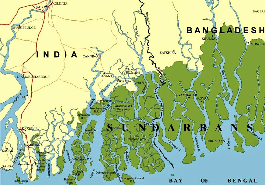
Sundarban, the largest mangrove forest, is situated in the southern part of Bangladesh adjacent to the Bay of Bengal and Ganga, Brahmaputra, Meghna river delta along with the West Bengal of India. The forest covers 10,000 square kilometers, of which about 6,000 square kilometers are situated in Bangladesh. It was declared World Heritage Site by UNESCO in 1997.
Sundarban is called the lunge of Bangladesh. The contribution of Sundarban has a multidimensional capacity. Sundarbans are part and parcel of Bangladesh, not only for ecological balance but also for economic affairs. But one-third of it has already dwindled, which results in serious environmental threats to Bangladesh.
Sundarban covers 40% of the forest areas of Bangladesh. Bangladesh is a highly vulnerable country to the threat of being submerged. It’s a natural railing to save Bangladesh from natural calamities. The largest mangrove forest protects Bangladesh from coastal erosion, tsunamis and surge storm. For example, Sundarban reduced the damage during cyclone Sidr in 2007 and cyclone Aila in 2009. The characteristics of mangrove forests slow the flow of water, preventing sediment deposition. Besides, the forest ecosystem, full of life, energy and enthusiasm and rich in flora and fauna, provides habitats for about 6540 aquatic and terrestrial species. About 5,700 species are vascular plants, and 840 species belong to forest wildlife (Akhond, 1999). Sundarban’s Tiger reserve is known to have the most significant number of tigers in the entire world.
Though it is not wise to evaluate the economic contribution of Sundarban because its contribution is invaluable, we find out the socio-economic inter-relations between Sunderban and habitats. Bangladesh agriculture-based country. Two third of the population are engaged in agriculture. Most of the people of the southern region depend on the Sundarban directly or indirectly for their livelihoods. People collect honey, timber, wood, leaves, organic medicine etc. Bangladesh is 5th in global fish production. The fisheries sector contributes 3-5% of GDP. There are a number of rivers which provide fish. Due to climate change, it is declaiming day by day.
Sunderban is a famous tourist spot also. Sundarban National Park, Kotka beach, Hiron point, and Dublar Char are famous tourist zones in Sundarban.
The most frightful news is that Sundarban has been troubled several times. Last year, a large ship carrying over 1,200 tons of coal sank in the southern Shela River. The ongoing debate on Rampal coal-based power plants has a question over harm to Sundarban. Specialists say that because of Rampal Project, the density of Nitrogen di Oxide and Sulfur di Oxide will be 54 micrograms, where the standard rate is 30 micrograms. Moreover, it will affect the entire ecosystem of Sundarban. That way, the environmentalist, students and civil society demand the reassessment of the project for the sake of Sundarban’s security. Policymakers should seek other options. Because there is no alternative to Sundarban!!
Relation between Climate Change and Migrant Crisis
Sharif Mustajib
student, International Relations
The University of Chittagong.

You made some decent points there. I did a search on the subject and found most people will consent with your site.